Private beta open — limited seats HydraLite Pro HydraLite Pro

Agricultural hydraulic design on real terrain

Lay out your irrigation network directly on your field’s orthophoto and contour lines. Hydraulic calculation with diagnostics, true longitudinal profile, and presentation-ready reports.

Windows · invite-only private beta · v0.1.27

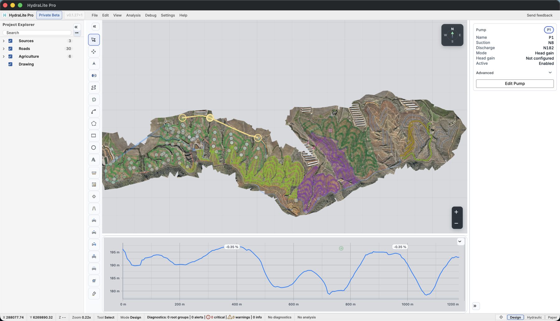
HydraLite Pro: irrigation network designed on a real orthophoto with terrain profile
Why HydraLite

Terrain rules. Your software should know it.

Designs that fail in the field rarely fail because of the formula — they fail because of the elevation nobody checked. HydraLite puts real topography at the center of design.

Real topography and orthophoto

Import your field survey — drone, GPS or cartography — and design on top of it. Every reach knows its elevation; every profile is the real one.

Calculation that explains

Pressures, velocities and losses per pipeline, with diagnostics that point at the problem and the real profile under every reach.

Traceable engineering

Every release documents its assumptions, validity ranges and limitations. Same model, same data, same results — always.

Current release capabilities

What HydraLite does today

Everything listed here ships in the version you install — each capability is verified on a real project before every release. What’s still in development is not promised.

TERRAINYour field, for realOrthophoto, contour lines with elevations, terrain and roads as project layers
DESIGNNetwork and irrigation systemsNodes, pipes with material and diameter, pipelines, systems and sectors in a layered explorer
ANALYSISHydraulic calculationPer pipeline or system, with elevation validation, diagnostics and status in the inspector
ANALYSISTrue longitudinal profileThe terrain profile under every route, integrated with calculation and reports
DESIGNDrawing and measurementPolylines, polygons, circles and text; snapping; distance and area measurement on the terrain
DELIVERYProfessional reportsPDF sheet with profile, bill of materials (CSV/PDF), hydraulic report and calculation memo with signatures

In development (not included yet): pumps with curve and operating point, energy and tariffs, transients. They will be announced once released.
How it works

From survey to drawing, without leaving the tool

1

Load your terrain

Your field’s orthophoto and elevation model. Projects are stored on your computer — never on our servers.

2

Design the network

Lay out sources, mains, pumping systems and sectors directly on the terrain, with the real profile under every reach.

3

Analyze and deliver

Run the hydraulic calculation with diagnostics and generate the calculation memo, bill of materials and project drawings.

Overview of a project in HydraLite Pro
HydraLite in action

Watch it work before you install it

Real recordings of the application on real projects — no mockups, no staging.

Video: recorrido completo de HydraLite Pro
Full walkthrough: from terrain to drawing
Promo video · coming soon
COMING SOON
Laying out a network on the orthophoto3 min · from survey to the first reach
COMING SOON
Calculating a pipeline4 min · diagnostics and real profile
COMING SOON
Memo, bill of materials and drawings3 min · presentation-ready reports
Early access

Private beta — limited seats

We’re onboarding irrigation designers and consultants who want to design a real project with HydraLite. Full access, direct support, and founder pricing at launch.

Apply for the beta

Signed Windows installer · automatic updates